
The U.S.-Mexico border is one of the most politicized technological spaces in the country, with leaders in both political parties supporting massive spending on border security and the so-called "Virtual Wall." Yet we see little debate over the negative impacts for human rights or the civil liberties of those who live in the borderlands. Despite all the political and media attention devoted to the border, most people hoping to write about, research, or learn how to identify the myriad technologies situated have to rely on images released selectively by Customs & Border Protection, copyright-restricted photographs taken by corporate press outlets or promotional advertisements from the vendors themselves.

To address this information gap, EFF is releasing a series of images taken along the U.S. Mexico-Border in California, Arizona, and New Mexico under a Creative Commons Attribution 3.0 license, which means they are free to use, so long as credit is given to EFF (see EFF's Copyright policy). Our goal is not only to ensure there are alternative and open sources of visual information to inform discourse, but to raise awareness of how surveillance is impacting communities along the border and the hundreds of millions of dollars being sunk into oppressive surveillance technologies.
Surveillance Towers
The images include various types of surveillance towers adopted by Customs & Border Protection over the last two decades:
- Integrated Fixed Towers (IFT). These structures are from the vendor Elbit Systems of America, part of an Israeli corporation that has come under criticism for its role in surveillance in Palestine. Some IFT towers are built using the same infrastructure as the earlier Secure Border Initiative (SBInet) program, which was widely considered a multi-billion-dollar boondoggle and canceled in January 2011. While there may be different IFT models along the border, the most common versions combine electro-optical and infrared sensors and radar and use solar panels.
- Remote Video Surveillance Systems (RVSS). These structures from the vendor General Dynamics are most commonly, but not exclusively, found along the border fence. The platform at the top usually includes two sensor rigs with electro-optical and infrared cameras and a laser illuminator. The RVSS towers along the southwestern border (California, Arizona, New Mexico, and the El Paso area in Texas) differ in design than some of the RVSS models in south Texas; those are not included in this photo collection.
- Autonomous Surveillance Towers (AST). These "Sentry" towers are made by Anduril Industries, founded by Oculus-creator Palmer Luckey. According to CBP, an AST "scans the environment with radar to detect movement, orients a camera to the location of the movement detected by the radar, and analyzes the imagery using algorithms to autonomously identify items of interest." In July 2020, CBP announced plans to acquire a total of 200 of these systems by the end of Fiscal Year 2022, a deal worth $250 million. EFF is publishing an image of one of these new towers installed in New Mexico along State Road 9; previously Anduril towers were only known to be located in Southern California and South Texas.
- Mobile Surveillance Capabilities (MSC) from the vendor FLIR, which are surveillance towers mounted in the back of trucks so that they can be transported around or parked semi-permanently at particular locations. While CBP has used these trucks for many years, in early 2021 FLIR announced a new $21 million contract with CBP that will include additional units with new technologies "that can track up to 500 objects at once at ranges greater than 10 miles." While these trucks do move around the region, they are often parked in certain established areas, including next to permanent surveillance towers.
CBP is currently in the early stages of the solicitation process for a massive expansion of this tower network on both the southern and northern border, according to an industry presentation from October. The "Integrated Surveillance Tower (IST) program is designed to "consolidate disparate surveillance tower systems under a single unified program structure and set of contracts," but it also contemplates upgrading 172 current RVSS towers and then adding 336 more, with the majority in California and Texas.
Tactical Aerostats
EFF's image set also includes two new tactical aerostats. First, the persistent ground surveillance (PGSS) tactical aerostat that was launched without notice over the summer in Nogales, AZ, surprising and angering the local community. Secondly, we photographed a new aerostat in southern New Mexico that had not been previously reported. A third aerostat will soon be launched in Sasabe, AZ-with a total of 17 planned in the next fiscal year, according to a CBP report.
These aerostats should not be confused with the "Tethered Aerostat Radar Systems," which are larger and permanently moored at air fields throughout the southern U.S. and Puerto Rico. TARS primarily use radar, while tactical aerostats include "day and night cameras to provide persistent, low-altitude surveillance, with a maximum range of 3,000 feet above ground level," CBP says. Tactical aerostats are tethered to trailer-like platforms that can be moved to other locations within a Border Patrol's area of responsibility.
EFF and the Border
EFF's photographs were gathered up close when possible, and using a long-range lens when not, by EFF staff during two trips to the U.S.-Mexico border. In addition to capturing these images, EFF met with the residents, activists, humanitarian organizations, law enforcement officials, and journalists whose work is directly impacted by the expansion of surveillance technology in their communities.
While officials in Washington, DC and state capitals talk in abstract and hyperbolic terms about a "virtual wall," there is nothing virtual at all about the surveillance for the people who live there. The towers break up the horizon and loom over their backyards. They can see the aerostats from the windows of their homes. This surveillance tech watches not just the border, and people crossing it, but also nearby towns and communities, on both sides, from air and the ground, and it can track them for miles, whether they're hiking, driving to visit relatives, or just minding their own business in solitude.
People who live, work, and cross the border have rights. We hope these photographs document the degree to which freedoms and privacy have been curtailed for people in the borderlands.
A sample of the images is below. You can find the entire annotated collection here.

An Anduril Sentry off CA-98 in Imperial County, CA

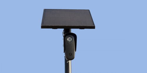
A Tactical Aerostat flying over State Road 9, Luna County, NM

An extreme close-up shot of the lens of an Integrated Fixed Tower (IFT) camera on Coronado Peak, Cochise County, AZ

A Mobile Surveillance Capability surveillance in Pima County, AZ