


Update: As of June 5 2026 the map and dataset has grown to 598 towers. We have also added the locations of Tethered Aerostat Radar Systems (TARS), Tactical Aerostat Systems (TAS), automated license plate readers and face recognition at Land Ports of Entry.
To provide researchers with the tools they need to analyze the impact of U.S. border security policy, EFF is releasing a new map and dataset of more than 290 surveillance towers installed by Customs and Border Protection (CBP) along the border with Mexico. Compiled using public records, satellite imagery, road trips, and even exploration in virtual reality, EFF's data serves as a living snapshot of the so-called "virtual wall," from the California coast to the lower tip of Texas. We've also included roughly 50 locations CBP has proposed for its next round of towers, as well as automated license plate readers (ALPRs) placed at Border Patrol checkpoints.
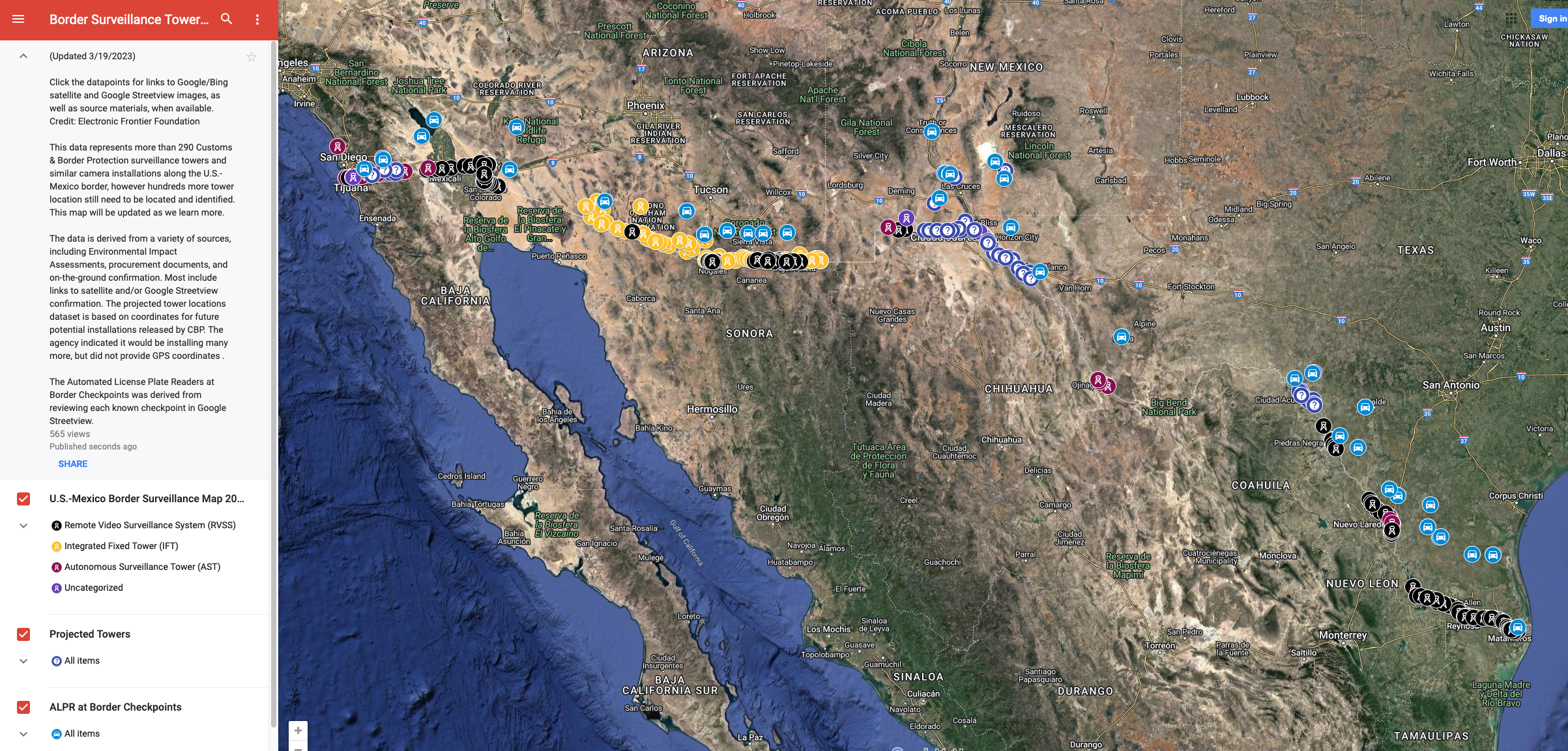
Click to launch interactive map. Google's Privacy Policy applies.
Download the dataset here. It is free to use and remix under EFF's Creative Commons Attribution License.
Surveillance towers along the border have had a troubled history. In the mid-2000s, the Secure Border Initiative aimed to place "SBInet" towers along the border, but only got as far as installing a few dozen in Arizona before bipartisan outcry over technical problems, cost, delays, and ineffectiveness resulted in it being shut down. Throughout the 2010s, CBP took another run at a tower-based system, resulting in disparate tower systems–the Integrated Fixed Tower (IFT) and Remote Video Surveillance System (RVSS)–provided by different vendors that could not interact with another. Despite spending more than a billion dollars since 2005, the Government Accountability Office concluded in 2017, CBP was "not yet positioned to fully quantify the impact these technologies have on its mission."
Now CBP (and its sub-division, U.S. Border Patrol) is planning yet another massive expansion of surveillance towers at the U.S.-Mexico border. Referred to as the "Integrated Surveillance Tower" (IST) or "Consolidated Tower and Surveillance Equipment" (CTSE) program, CBP intends to bring the RVSS and IFT systems under one program and, over the next decade, begin upgrading 135 existing towers with new capabilities, technologies and sensors, while also installing 307 new towers along the Southern border. CBP has indicated these towers would help fill in surveillance gaps caused by the planned conclusion of its tactical aerostat program.
The tower systems are able to automatically detect and track objects up to 7.5 miles away and assist agents in classifying objects 3 miles away, depending on regional requirements. Dozens more towers will be added at the Canadian border. Meanwhile CBP is in the process of installing 200 Autonomous Surveillance Towers (ASTs) from Anduril Industries that are controlled by artificial intelligence software, which will also be part of the IST program. In the short term, CBP has earmarked $204 million for this program in its 2023 and 2024 budgets, which covers the deployment of 74 ASTs by the end of FY 2024 and 100 new towers by the end of FY 2025.

A more granular breakdown of CBP's tower plan is available here.
That's why it's important to document the towers as they exist today and continue to track them as the system expands. Our current map is the most comprehensive available to the public, but it still depicts only a portion of what's already been installed and what will be installed in the years ahead.
This data will allow for many types of research, on issues ranging from border policy to environmental impact. For example, the placement of the towers undermines the myth that border surveillance only affects unpopulated rural areas: a large number of the existing and planned targets are positioned within densely populated urban areas. Also, journalists traveling the border need to identify the location of towers in order to document them and interview residents who live and work under constant surveillance. Border security researchers can use this data to independently evaluate whether the towers meet CBP's stated goals, such as intercepting drug smuggling and human trafficking. Sam Chambers, a researcher at University of Arizona, is currently studying whether the placement of towers results in migrants taking more perilous routes across the desert.
"The data provided by EFF are an invaluable resource for researchers like myself," Chambers says. "It allows us to document the actual impacts of a 'virtual wall' on undocumented border crossers—by comparison of the locations and capabilities with records of known border crosser mortalities. It also makes it possible to more precisely estimate the increased physiological toll resulting from specific surveillance technologies. I expect to use this resource to expand on my past work and bring light to the harms brought upon by what would otherwise be called a 'smart' and 'humane' alternative."
About the Towers
Currently, the map includes three primary styles of towers implemented by CBP:
An Integrated Fixed Tower in Cochise County, Ariz.
Integrated Fixed Towers (IFT). These structures are from vendor Elbit Systems of America, part of an Israeli corporation that has come under criticism for its role in surveillance in Palestine. Elbit previously was a subcontractor on the failed SBInet project, and has built many of the new towers at the same locations of the original SBInet towers. IFTs are exclusively found in Arizona, with several controversial towers installed on tribal lands owned by the Tohono O'odham nation. IFTs can reportedly detect a person up to 7.5 miles away.
A Remote Video Surveillance System in Nogales, Ariz.
Remote Video Surveillance Systems (RVSS). These structures from vendor General Dynamics are most commonly, but not exclusively, found near the border fence. The platform at the top usually includes two sensor rigs with electro-optical and infrared cameras and a laser illuminator. The monopole version of the RVSS is found throughout the Southwest, but a new model— the "relocatable RVSS" (R-RVSS)—has been installed throughout the Rio Grande Valley in South Texas. RVSSs can reportedly detect a person up to 7.5 miles away, however the range may vary depending on the particular regional requirement.

An Autonomous Surveillance Tower in Imperial County, Calif.
Autonomous Surveillance Towers (AST). These "Sentry" towers are made by Anduril Industries, founded by Oculus creator Palmer Luckey. According to CBP, an AST "scans the environment with radar to detect movement, orients a camera to the location of the movement detected by the radar, and analyzes the imagery using algorithms to autonomously identify items of interest." In July 2020, CBP announced plans to acquire 200 of these towers by the end of Fiscal Year 2022, a deal worth $250 million. These towers are heavily concentrated in Southern California, with patches popping up in southern New Mexico and the Big Bend, Laredo, and Del Rio Border Patrol sectors in Texas. Because they are so new, and have yet to appear in updated, publicly available satellite imagery, we have only documented a small portion of these installations in our data set. ASTs can detect a person up to 1.7 miles away and a vehicle 2.2 miles away, according to company materials.
The map also includes unusual and novel surveillance towers, such as a new Elbit tower that was installed on the Cochise County Community College campus and a tower installed on the property of Warren Buffet's son's ranch, both near Douglas, Ariz. Another Anduril tower was located 30 miles north of the San Diego border, where it watches the Pacific Ocean from the cliffs near the Del Mar dog beach. We have also included towers installed at inland border checkpoints as well as a number of towers of which we were unable to conclusively determine the models.
We will continue to update and add to the data as we document new towers and technologies. If you are aware of a tower that isn't on our map, or know of a tower that has been relocated, please email aos@eff.org.
Automated License Plate Readers (ALPRs). We have also mapped out 39 Border Patrol checkpoints where ALPR systems have been installed, either by CBP or the Drug Enforcement Administration. These cameras collect the license plates of vehicles that pass, attach a timestamp and GPS coordinates, then upload that data to a searchable database. The data is stored for 15 years—far longer than the retention period of any state or local law enforcement agency. CBP's ALPR vendor, Perceptics, was breached in 2019, resulting in the leak of 105,000 license plate images. A year later, the Government Accountability Office concluded that only about half of border checkpoints were using ALPR systems as intended with a system for documenting the outcomes of secondary inspections of vehicles.
How We Did It
The number of journalists traveling to the border to conduct first hand reporting on surveillance technology has increased in the last few years. However, reporters often have had to rely on CBP and Border Patrol to provide access to these towers, or on locals who know the location of a handful of towers. When EFF began visiting the border in 2022, it became clear there was a need for a map so people could independently visit and examine surveillance infrastructure.
We began with procurement documents through Sam.gov, where CBP had disclosed the approved locations for a series of new towers; moving backward from there, we were able to find additional locations noted in earlier purchasing records. We also began examining Environmental Assessments that CBP has published online, which often include GPS coordinates, maps, and verbal descriptions of proposed towers. Using this data, we scoured Google Maps' satellite view, Bing Maps' aerial view, and Google Streetview to confirm whether the towers had been installed.
We also hunted for towers using a virtual reality app called Wander, essentially an immersive version of Google Streetview, on a Meta Quest 2 headset. We would simply drop ourselves at various locations along the border and look for towers; often the Mexican side provided a clearer and closer view of technology installed along the wall. The app also allowed us to scan the landscape using a Google satellite map the size of a movie theater screen. This also let us slowly move through border checkpoints, identifying surveillance towers and automated license plate readers.
Finally, we discovered several towers by visiting the border in person. For example, we located an Anduril tower in southern New Mexico that had so far not appeared in any public records or been captured by publicly available satellite imagery. You can view more detailed photos we released into the public commons on Wikimedia.
You can watch a short presentation on our methodology from the Mapping USA 2022 conference here.
University of Nevada, Reno Reynolds School of Journalism student Michael Rubio assisted in the visual investigations of surveillance towers. EFF staff Haley Pederson and Christian Romero also helped confirm tower locations.


")